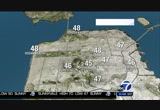
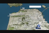
last night, napa, forecasting 42. they got down to 42 this morning but we'll add a few more degrees. so 50 tonight. here's the setup. high pressure, storm track being shoved to the north of us and that's where all the rain is. highs will continue to build in, and then that will bring us a slight offshore wind component and that means temperatures will heat up a little more. so look for new record highs for your monday afternoon. by tuesday, the sea breeze will kick back in and temperatures will could here's how your day goes. 1:00, 2:00, 3:00, look for 80s and near 70 see coast. here's how tomorrow will plan out. high for oakland tomorrow, 82. the warmest day this week. and then as the low clouds and fog move in by thursday, friday, saturday, the temperature starts to trend downed. those in the livermore valley area, knocking on 90 degrees tomorrow, and then temperatures trend back done into the 70s by thursday, friday, saturday. so here's a look at tomorrow. 86, morgan hill and san jose. peninsula, warm temperatures,
 Live Music Archive
 Librivox Free Audio
 Metropolitan Museum
 Cleveland Museum of Art
 Internet Arcade
 Console Living Room
 Books to Borrow
 Open Library
 TV News
 Understanding 9/11